For a quick idea of where the mentioned places are, see the Uppsala climbing areas map.
This is a selection of places I have been to, but it is not a complete list. Other sources are linked at the bottom of this page.
Distance from Uppsala : 7km (10 mins drive + 10 mins walk)
Location : E1600600 N6633500 Lurbo, Uppsala. (Gröna Kartan 11I NV Uppsala)
Aspect : Buried in forest.
Directions : Take Dag Hammarskjöldsväg south from town, take a right on to Vårdsätravägen at the traffic lights by Ulleråker and continue to the right turn signed to Hammarskog. Immediately after taking that turn there is a bridge over Hågaån, and parking on the left round a bend. Then walk 10 mins north on the footpath along Hågadalen, and try not to miss the cliffs hidden in the trees.
Climbing :
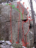
There are several formations here, but the one that dominates is ~15m high,
has a couple of good grade 5 crack climbs, but mostly faces in grades 6 and up.
Not good for beginners, crowded with more than a couple of pairs climbing,
few trees near the top for anchors (but one bolt), dries out slowly,
and mosquito hell in summer.
On the other hand, you will normally be alone, and it is very close for a
quick evening's practice.
In the winter, Stöldförsök's nice crack system is good for practicing clean aiding.
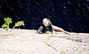
Click on the picture for route details.
Distance from Uppsala : 12km (15 mins drive + 10 mins walk)
Location : E1599974 N6629857 On the back road to Hammarskog. (Gröna Kartan 11H NO Enköping)
Aspect : South-west, facing on to crop field.
Directions : Follow the directions for Predikstolen (above), but keep going towards Hammarskog, and you will eventually come to a junction signed Uppsala Näs K:A to the left. Take this for 1km, then turn right up the allée that is the back way to Hammarskog. After a couple of kilometers you will see parking for Dalkarlskärret on the left. Cross the road and walk 10 mins north-west around the lake, and the wall is on the right.
Climbing :
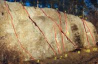
This wall is 6-8m high and circa 20m long, with
a handful of short cracks and faces with routes in grades from 4 to 8.
Very suitable for beginners, with good trees above for top-rope anchors,
and cracks for setting own protection. No bolts or artificial anchors.
Dries quickly, gets very busy on nice sunny weekends.
Click on the picture for route details.
Distance from Uppsala : 20km (15 mins drive + 5 mins walk)
Location : E1589476 N6634948, Hagby, Vänge. (Gröna Kartan 11H NO Enköping)
Aspect : South facing, in clearing in forest.
Directions : Take 72 to Vänge and take the left turn signed to Hagby. Drive 5km south and you will see a football field on your left. Immediately before that take the left turn signed to Nyborg and drive 200m to a clearing on the right where you can park if it is not being used for storing timber. Then walk 100m further up the road where you will see a track going into the forest on your left. Follow this 300m north to the cliff.
Climbing :
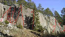
The rock is maybe 10m tall with mostly face climbing, but a couple of nice
finger cracks. There are no bolts yet, and there has been very little climbing here so far.
It's a very pleasant, open location, and the rock is very rough with great friction, but there are not that many
routes, so it's best to be there alone.
To maintain good relations with the landowner, climbers are asked to keep away from Filke
during the month of October.
Click on the picture for some selected routes.
For a description of routes we've climbed here, go to the climbing database.
Distance from Uppsala : 60km (40 mins drive + 5 mins walk)
Location : E1611000 N6597900 Kungsängen, Stockholm. (Blå Kartan 106 Stockholm)
Aspect : South-east facing, overlooking a bay on lake Mälaren.
Directions : Leave E4 south at Rotebro and take 267 west towards Enköping. Before you leave Stäksön, park under the motorway bridge that takes E18 over Ryssgraven to Kungsängen, then cross the railway lines (quickly) and walk 5 mins north around the bay.
Climbing :
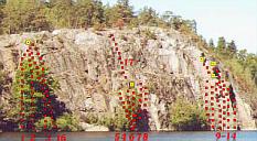
100m long cliffs, 25m high, half of them dropping directly into the lake.
There about a dozen bolted or easily-protected routes in grades 4 to 6,
the rock is good and solid, and falls are generally clean. There are several
anchors on the top.
Quite a nice little training spot, if you don't mind the motorway noise. Much quieter on a Sunday.
Click on the picture for route details.
For a description of routes we've climbed here, go to the climbing database.

Distance from Uppsala : 35km (30 mins drive + 1 min walk)
Location : E1571339 N6642206, Vittinge (Gröna Kartan 11H NV Enköping)
Aspect : South facing, in forest.
Directions : Take route 72 to Vittinge and turn left at the sign to Hårsbäck, which takes you over the railway line. After 100m turn left on to Lillbovägen, then after 400m turn right at the T-junction. This road goes east about 1km before being closed by a barrier. About 100m before this there is parking for several cars on the right. If you walk to the barrier you can just about see the cliffs 30m off to your left (north).
Climbing :
The cliffs extend more than 50m and are at least 8m high. A couple of hard routes have
been bolted, and there are plenty of trees for top anchors, but there's not much to lead.
The place felt a bit claustraphobic to me, but I haven't climbed there yet. It looks like it has a lot of potential routes.
It is on Upplandsleden, and Tenasjön is less than a kilometer away for a swim on the way home.

Distance from Uppsala : 2km (15 mins walk)
Location : E1602068 N6636696, Stadsskogen, Uppsala (Gröna Kartan 11I NV Uppsala)
Aspect : In sparse forest. Pleasant.
Directions : Follow the illuminated running track until you see the wall. It's between Vallstigen and Norra Norbyvägen.
Climbing : Two sections of vertical wall built from large granite blocks, up to 4m high, and maybe 20m in length. Perhaps a little too easy for serious bouldering, but its proximity to town makes it very attractive for teaching beginners rope work, for practicing new techniques, or if you only have an hour to spare.
Distance from Uppsala : 20km (30 mins drive)
Location : E1619600 N664000, Lötsjön, Länna, Uppsala (Blå Kartan 116 Norrtälje)
Aspect : South-east facing over lake.
Directions : Take road 282 east from Uppsala, turn right on to dirt road at the little wooden sign pointing to 'badplats', and follow this another 10 mins down to the parking for the family bathing spot. Then hike another 5 mins up on to the cliff along the water.
Climbing : Deep-water soloing. 8m high, 15m long cliff dropping into the water. Several good lines to combine with an afternoon of swimming. The easiest would be a 4 in dry shoes, but feels like a 6 with wet bare feet. Starts very steep and then levels off to an easy slab. An uncontrolled fall from the top hurts but doesn't maim.
 Distance from Uppsala : 40km (30 mins + 30 mins walk)
Location : E1614200 N6607300 Upplands Väsby. (Blå Kartan 106 Stockholm)
Aspect : West facing, overlooking lake Mälaren, heavily treed at base.
Directions : Leave E4 south at Norrsunda and follow signs west to Rosersberg until just before the house, then south towards Rosendal. Park by the river where the road turns private, then walk 10 mins west and 20 mins north to the fornborg. The cliffs are just beyond and on the left.
Climbing :
20-odd routes almost all in grades 6 and 7. Not a good place for beginners,
with just one dislocated 5+. At least 15m high.
It's a nice enough place, but a long way to go for small rewards.

Distance from Uppsala : 70km (50 mins + 15 mins walk)
Location : E1611091 N6588501 Jakobsberg. (Blå Kartan 106 Stockholm)
Aspect : West facing, by lake Mälaren, heavily treed.
Directions : Kind of difficult. See Stockholms Nätförare
Climbing :
10 to 15m high walls in the woods by the lake. Mostly hard sport routes from grade 6 up. Not so good for trad climbing.
Dries slowly.
For a description of routes we've climbed here, go to the climbing database.

Distance from Uppsala : 90km (80mins train/bus)
Location : E1629300 N6577800 Nacka. (Blå Kartan 106 Stockholm)
Aspect : North-west facing, by canal.
Directions : Train to Stockholm Centralen, T-bana to Slussen, bus to Londonviadukten
Climbing :
20m high blasted wall dropping into Danvikskanal. 15 or so mostly hard sports routes. Ugly climbing, nasty falls,
and scary old anchors, but beautiful setting by the canal and fun to visit if you are in Stockholm anyway.
Dries quickly.
See also Stockholms Nätförare
,+Häggsta,+Stockholm)
Distance from Uppsala : 100km (60 mins drive + 5 mins walk)
Location : E1618400 N6570300 Huddinge, Stockholm. (Blå Kartan 106 Stockholm)
Aspect : South facing, overlooking lake Mälaren.
Directions : Leave E4 south at Fittja and take 259 east towards Huddinge until there is a right turn to St. Botvidskyrka, park in the car park by the church and walk 5 mins west down a path to the right of the church.
Climbing :
Stockholm's oldest climbing area. Over 100 named routes from grade 3 to 8.
Something for everyone - 40m routes, faces, cracks, bolts, anchors, water.
The down side is that the rock is quite loose, with a scary amount of fresh debris at the bottom, protection is sketchy,
and the walls are not often cleanly vertical - a lead fall would generally be rather unpleasant.
It feels more like mountaineering than sport climbing. Take a helmet.
For a description of routes we've climbed here, go to the climbing database.

Distance from Uppsala : 120km (70 mins drive + 10 mins walk)
Location : E1645200 N656900 Tyresö, south-east of Stockholm.
Aspect : West facing, forested but overlooking Baltic bay at the top.
Directions : Hard to describe, see map in Stockholm's Föraren.
Climbing :
25m high, 100m long cliff with ~ 30 named crack and face routes in grades 4+ and up.
We only tried one route (Skamvrål, 4+), which is pretty good (and featured on the cover
of the 1996 Stockholm Climbing Guide). It's a bit messy to get down
from the path at the top - either a hard-to-find path, or a tricky rappel over an overhang
down on to heavy talus, on which it is easy to get into trouble with a big pack. The day we were there
two people got stuck on the way down and needed help with an extra rope to get down.
Worth more exploring.

Distance from Uppsala : 120km (80 mins drive + 10 mins walk)
Location : E1613384 N6550403 Fituna, south of Stockholm.
Aspect : South-west facing, forested, but great view over fields to Östersjön at the top.
Directions : Take E4 south through Stockholm to the junction signed to Tumba, and turn off on 226. Follow this all the way to Vårsta, where you turn left on to 225, signed to Nynäshamn. After 15km turn right at the sign to Fituna. Proceed 200m and turn left into the first dirt track. Drive about 100m and park at the crossroads where there is room for about half a dozen cars. Then walk 600m SW to the top of the cliffs. This route has been negotiated between SKK and the not-so-climber-friendly locals, so avoid parking elsewhere.
Climbing :
30m high, 100m long steep wall with ~ 30 named crack and face routes in grades 5 and up.
Great climbing. Steep, high-friction rock. Long, consistent routes. Good protection and clean falls.
The downside is that it's so good that it gets crowded at weekends.
Click here for pictures from Grönbrinksberget.
For a description of routes we've climbed here, go to the climbing database.

Distance from Uppsala : 125km (90 mins drive + 5 mins walk)
Location : E1611577 N6548296 Fituna, south of Stockholm.
Aspect : West facing, open, great view over Östersjön at the top.
Directions : Take E4 south through Stockholm to the junction signed to Tumba, and turn off on 226. Follow this all the way to Vårsta, where you turn left on to 225, signed to Nynäshamn. After 15km turn right at the sign to Fituna. Proceed 2km (past Grönbrinksberget) and turn right into an unsigned road. Drive a couple of kilometers down that road, which deteriorates into a dirt track and eventually stops. Park there, walk a little way into the forest and turn left off the path and a hard-to-describe point. It's another couple of minutes from there to the cliff.
Climbing :
10m high, 30m long steep wall with ~ 40 named crack and face routes in grades 4 and up.
Something for everyone from beginners to expert. Good protection and clean falls.

Distance from Uppsala : 100km (60 mins drive + 5 mins walk)
Location : E1642941 N6581278, Gustavsberg, Stockholm.
Aspect : South-west facing, by the water.
Directions : See Stockholms nätförare
Climbing :
A recently-developed area with potential for more routes. Smooth, rounded, slippery rock
that demands good technique, especially friction moves. You can't cheat and use violence
to get past difficulties. 40m high, 50m long with about 30 routes equally divided
between easier trad routes and harder sports routes. Protection is not easy, and falls
are nasty, so it's more fun to second here. There are some anchors at the top but it's
a long walk to set up top ropes. But it's a very pleasant location, and worth a visit.
More info and topos are at the Stockholms nätförare
For a description of routes we've climbed here, go to the climbing database.

Distance from Uppsala : 150km (2 hours drive + 5 mins walk)
Location : Koppartorp, Nyköping.
Aspect : South-west facing, open.
Directions : I don't remember clearly. Sorry.
Climbing :
This is very much a trad climbing area, with very few bolts or even top anchors. The cliff is about 400m long
and 50m high, but is broken up into separate sections on different levels, so only a few of the 100 or so routes
go all the way up continuously. There are plenty of nice, easily protected cracks in the grade 4 to 5 range,
so it's a great place to learn to lead. The rock is sound, and the atmosphere pleasant. Definitely worth a visit
if you don't mind the driving. Camping is available under the cliff.
For a description of routes we've climbed here, go to the climbing database.
Distance from Uppsala : 220km (2 hours 15min drive + 5 mins walk)
Location : E1518363 N6505850 Kolmårdsskogen, Norrköping.
Aspect : South facing, mostly open, some cliffs drop into lake.
Directions : Will come later...
Climbing :
This is a beautiful area, a great place to visit for a weekend, with good camping all over.
There are around 200 named routes dotted around on a dozen cliffs on the lake.
There are not so many easy routes, and they are often steep and sustained, but there
are a dozen routes around grade 4 for beginners.
The highest cliff is around 35m high, but most are around 20m.
For a description of routes we've climbed here, go to the climbing database.

This page is not intended to provide exhaustive information on these areas,
but to help you choose where to go for an evening/day/weekend from Uppsala.
For more information, try : Sverigeforaren, Uppsala klätterklubb
and Utsidan,
and for bouldering in Nåsten, see The Uppsala Boulderguide.
Indoor gyms are at Stallet in Glunten, Crux in Librobäck, and Friluftsfämjandet in Sunnersta.
For courses and guiding by an authorised instructor in Uppsala, try Klätterkonsulten.
You may also want to play with our climbing database at : http://xray.bmc.uu.se/markh/php/clog.php
For those not familiar with Swedish (German) grades, here are some rough comparisons with the YDS :
5=5.7, 5+=5.8, 6-=5.9, 6=5.10a, 7=5.11a, 8=5.12a.
This document is : http://xray.bmc.uu.se/markh/climbing/climbing_areas.html
Mail me with suggestions/corrections. Mark Harris